
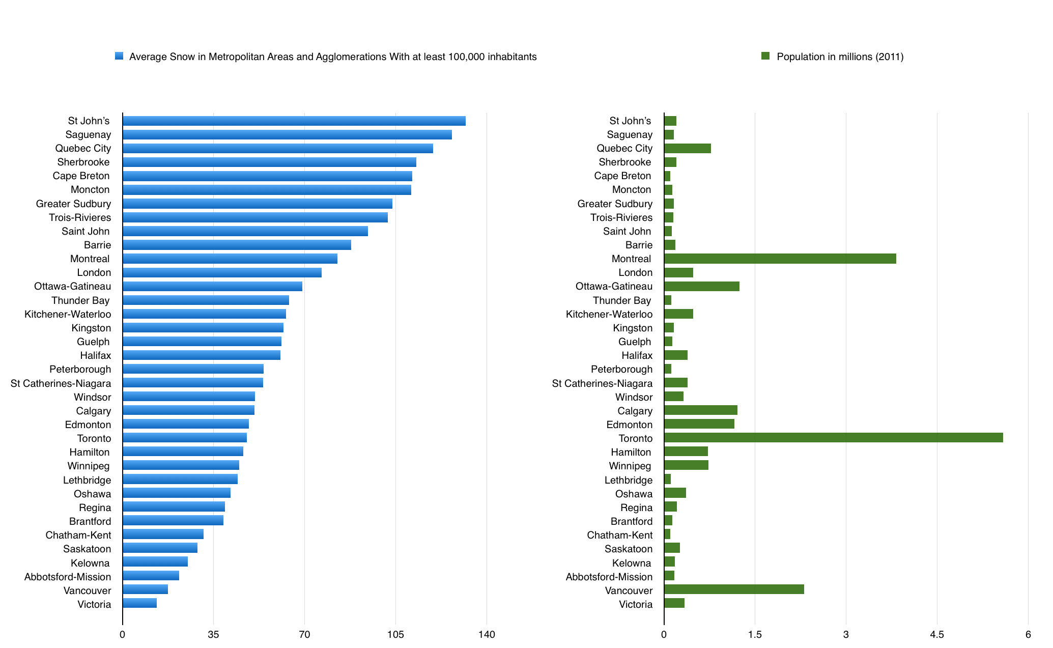
If extremely high taxes on greenhouse gas emissions were to be enacted worldwide, which part of Ontario would be poised to lead in terms of population growth and economic development as a result?
My guess would be St Catharines-Niagara, which at the moment is Canada’s 12th most populous census metropolitan area (just ahead of Halifax-Dartmouth), home to approximately 400,000 people.
A low-emissions city should at least a few of the following five characteristics, all of which define Niagara. One, it should be easily accessible by barge, as water remains far and away the most fuel-efficient mode of transportation. Two, it should not have much suburban sprawl. Three, it should be located close to other major cities in order to create urban economies of scale. Four, it should have a mild climate: not too cold or snowy in the winter, not too hot in the summer. And five, it should have an abundant source of clean power — and ideally also the ability to store up its energy in order to assist clean but intermittent power sources like solar, wind, and run-of-river hydro.
1. Water Transport
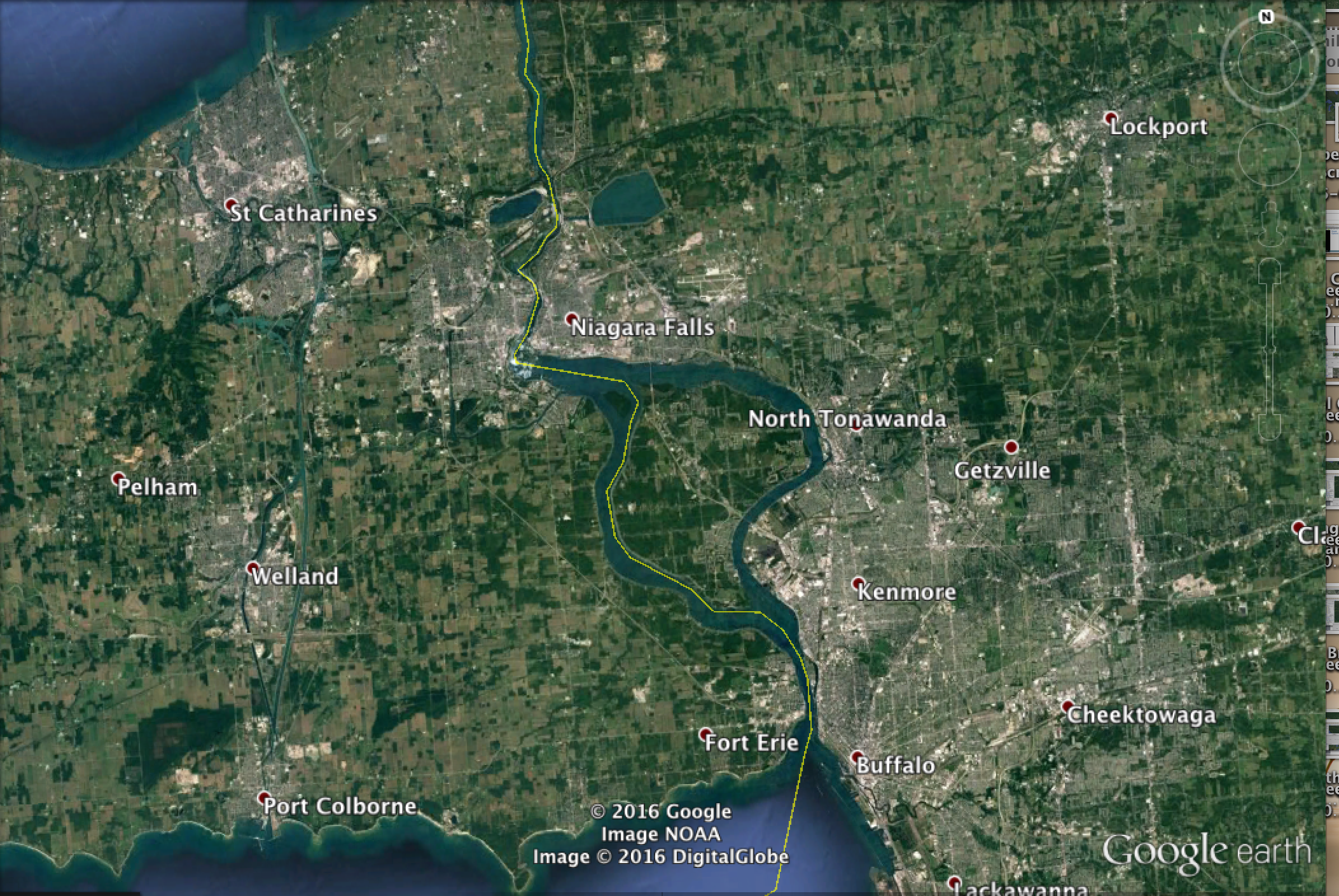
St Catharines-Niagara is one of only two urban areas in Canada or the US to be situated on more than one Great Lake. (The other is Sault St Marie). It links Lake Ontario to Lake Erie via the Welland Canal, a canal 43 km long and, in most places, 100-150 metres wide. The canal has seven locks on its northern end and one lock on its southern end; it takes ships around 10 hours to cross in full. However it has a lock-free middle stretch that is close to 25 km long, next to the city of Welland (pop. 50,000). It runs perpendicular to the Erie Canal, the longest shipping canal in the United States, which links Niagara Falls and Buffalo to New York City and Lake Champlain via the navigable Hudson River, passing by Rochester, Syracuse, and Albany along the way.

Canals, when they are not frozen in the winter, are in many ways the ideal form of water transportation. They lack the difficulties of rivers (bends, rapids, shallows, etc.) and seas (storms, tides, waves, etc.), and are not too wide to make building bridges or tunnels across them too expensive. According to the New York Times, when discussing the increased use of Erie Canal in 2008 when fuel prices were high, “one gallon of diesel pulls one ton of cargo 59 miles by truck, 202 miles by train and 514 miles by canal barge… A single barge can carry 3,000 tons, enough to replace 100 trucks”.
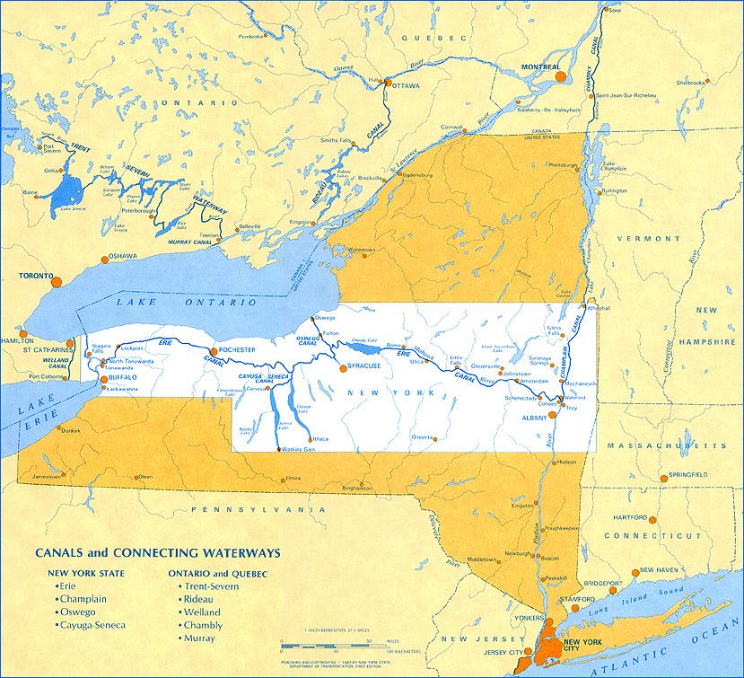
Erie Canal
As recently as the 1890s, prior to the modern age of highways, cars, and trucks, the Erie Canal allowed Buffalo to become the eighth most populous in the US and fourth most populous inland city in the US. And while Niagara never shared in Buffalo’s prominence (in part as it was too close to the US border for comfort; it was captured in the War of 1812, and became the refuge for William Lyon Mackenzie and his supporters during the Upper Canada Rebellion in 1837-38), the adjacent city of Hamilton did. Hamilton was Canada’s fourth most populous city during the 1890s, and was about half as populous as Toronto in 1870. Today, in comparison, Hamilton is only around 13 percent as populous as Toronto.
As land transport became dominant, however, Hamilton found itself blocked in by the Hamilton Harbour (which until then had been the main source of its success) as well as by the Niagara Escarpment. Toronto, in contrast, has been able to expand barrier-free, now reaching to Lake Simcoe in the north, Oshawa and Clarington in the east, and Hamilton’s suburbs in the west.


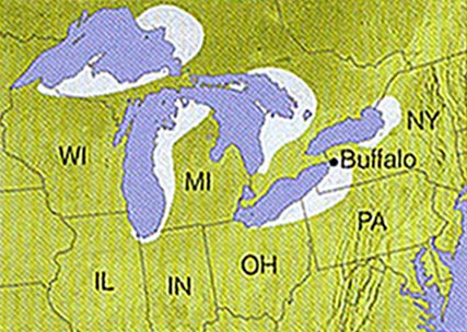
Niagara Escarpment
Admittedly, it is still quite expensive to build bridges across harbours or wide canals; they must be either high enough to let large ships pass below, or else be lift-bridges. The Welland Canal overall has two tunnels and ten bridges, all but one of which are lift-bridges. Given that the population of the region is split by the canal (St Catharines and Hamilton are to its west, Niagara Falls and Buffalo are to its east), these lift-bridges and tunnel crossings could lead to traffic bottlenecks if its population or economic activity were to experience growth.
This canal-crossing problem can be managed, however, by switching over from cars to public transit. Luckily for St Catharines-Niagara, such a switch which would be necessary anyway if greenhouse gas emissions were to be highly taxed.
Public transit, including new transit services like Car2Go, Uber, and UberPool, can allow canals to be crossed more easily via bridge or tunnel, by reducing traffic bottlenecks and by letting its passengers relax rather than drive when there are traffic bottlenecks. In addition, public transit can allow for easier canal crossings via boat, pedestrian bridge, cable car, or even ice-sled, by making transit available upon crossing. For the same reason, crossing canals will also become easier as parking apps like Rover and PocketParker become common (and if cars that come equipped with parallel parking sensors or can parallel park themselves become common), as people will be able to park a car easily on one side of the canal and then take public transit after crossing.
In the St Catharines-Niagara area, public transit will be similarly useful in helping to cross the Niagara River (which is one of the widest and, in places, the most treacherous rivers in southern Ontario), Hamilton Harbour (which has two bridges crossing it at present, and no tunnels), and perhaps even the 45 km Lake Ontario shortcut that separates St Catharines (and Buffalo) from Toronto.
2. Suburban Sprawl
St Catharines-Niagara, as well as the nearby urban areas of Hamilton and Kitchener-Waterloo, are among the cities with the highest population density in Canada. Apart from Toronto, Montreal, and Vancouver, it is Kitchener-Waterloo and Hamilton that have the highest population densities among urban areas in Canada according to the 2011 census, and St Catharines-Niagara has the seventh highest; though if you were include the sister-city of Niagara Falls, NY. St Catharines-Niagara would rise two or three spots. St Catharines has a significantly higher population density than cities like Ottawa, Edmonton, Kingston, London, Halifax, Winnipeg, or Quebec City.
If, moreover, suburban sprawl in general is reversed as a result of eco-taxes, Niagara may be particularly well-placed to benefit. This is because many of the big cities around Niagara — notably Buffalo and Toronto, but also Detroit and Cleveland — have sprawled away from Niagara during their recent generations of suburbanization. Toronto has sprawled north, away from Lake Ontario: northern Toronto suburbs like King city, Caledon, and Whitchurch-Stoufville tend have population densities that are far lower than in suburbs closer to the lake, like Mississauga, Oakville, and Oshawa — nearly 30 times lower in the case of Caledon compared to Mississauga. Indeed some of Toronto’s lakeside suburbs, particularly to its west (towards Hamilton and Niagara), are themselves among the cities with the highest population densities in the country. Toronto’s easternmost suburbs though, like Clarington and Scugog, have relatively low densities too.
Buffalo’s suburbs sprawl away from the border with Niagara, and Detroit’s sprawl away from Windsor (which is 315 km from St Catharines). Cleveland’s suburbs have sprawled away from Lake Erie, meanwhile, more to the west and south than in the direction of Buffalo and Niagara. If, then, suburban sprawl gives way to urban re-densification, it could lead to population growth along the coasts of Lake Ontario and Lake Erie, which Niagara shares, as well as along the Buffalo and Detroit borders with Canada, which Niagara either shares or is at least not too far away from.
Another energy advantage of de-suburbanization is that it frees up land to be re-converted into farmland. This is important, as importing food is highly energy-intensive; food is much more bulky than most other goods, and also often requires refrigeration or freezing while it is being transported. This means that areas that are not suitable to agriculture — areas that include most of Ontario, as the Canadian Shield generally is not farmable in the economic sense — will not benefit as much from de-surbanization (in an eco-tax world) as areas that are best suited to be used for agriculture, which for Ontario is Southwestern Ontario and adjacent areas of the United States.
3. Proximity to Major Cities
St Catharines is around 50km from Toronto by way of Lake Ontario and about 100 km from Toronto via land. To put that into perspective, Oshawa, Burlington, and Newmarket, all three of which are in the Greater Toronto Area, are around 45 km from downtown Toronto, and Barrie is around 85 km from downtown Toronto. St Catharines is also around 40 km from downtown Buffalo (and Niagara Falls is less than 30 km from downtown Buffalo), 65 km from downtown Hamilton, 120 km from Kitchener-Waterloo and from Rochester, 270 km from Cleveland, 300 km from Pittsburgh, and 320 km from Detroit, and 500 km from New York City and Washington, D.C.
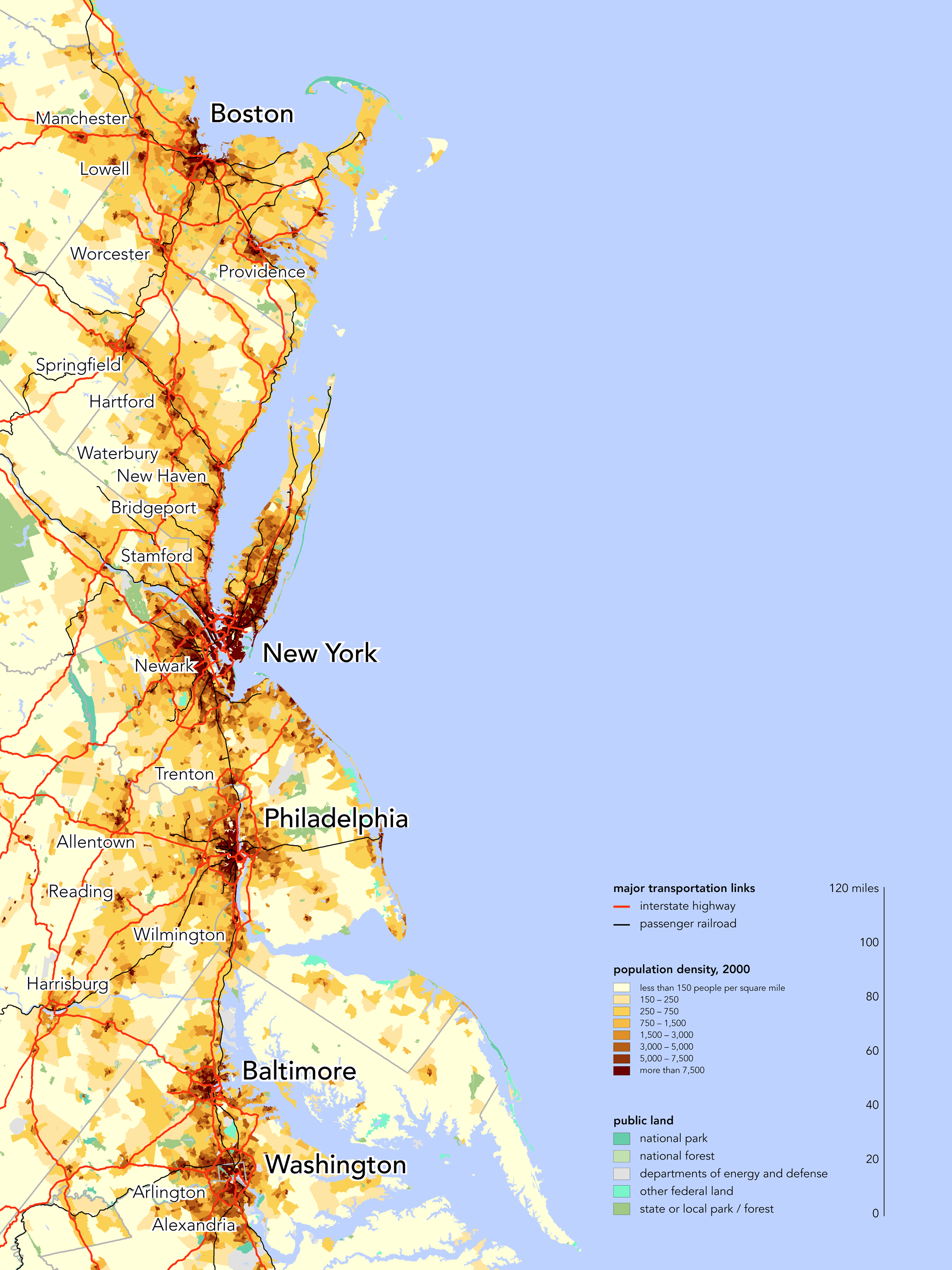
St Catharine's proximity to the New York City-to-Washington “Megalopolis” is unique and, in an eco-tax world, could be economically significant. If you extend the Megalopolis all the way north to Boston, however, then St Catharines’ proximity is less unique, as Ottawa and Kingston are both closer to Boston than St Catharines is. That said, the population density of the area between New York and Boston is quite a bit less than between New York City and Washington, so it is not clear Boston really should be counted as part of the Megalopolis core. St Catharines is also around 40 km closer to New York City and 250 km closer to Washington than Ottawa is, whereas Ottawa is only around 160 km closer to Boston than St Catharines is. Only Kingston then, among notable Ontario cities, can be said to be closer in proximity to the Megalopolis than St Catharines is.
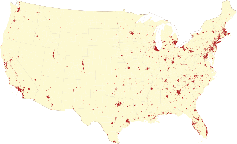
Population density, US
4. Climate
Niagara, because of its relatively southern location and the temperate effect of the Great Lakes that surround it, has a mild climate compared to most other cities in Ontario. It tends to be around a degree warmer than Toronto in the winter and a degree cooler than Toronto in the summer, and it is much milder than the weather in more northern cities like Ottawa or Thunder Bay. It is also located outside any of the Great Lakes Snowbelts, unlike, for example, Sudbury or Barrie.
Niagara’s position next to the US border may also be significant, as eco-taxes could lead Americans to come north to where the climate is more mild, at least during the summer. The average annual daily temperature highs in Buffalo is 14 degrees celsius, compared, for example, to 29 degrees for Miami or 31 degrees for Phoenix. Cool climate zones may also end up using more eco-friendly energy for heating than hot climates do for cooling, because the weather gets coldest at night when there are typically surpluses of electricity available (including low-carbon sources, like wind, base-load nuclear, and run-of-river hydro), whereas it is hottest during the day when no such energy surpluses typically exist. Admittedly only seven percent or so of American households use electric heaters, but a high eco-tax could cause them to be adopted more widely. Plus, it is possible to stay warm using clothing and blankets rather cranking the heat.
The arid climate and diffuse population settlement in the US Southwest in particular leads to a high energy footprint. Any extended drought in the Southwest, for example, would necessitate water desalination, water treatment, or increased food imports, all three of which are extremely energy-intensive. The most extreme of these, Las Vegas, which is a gambling and tourism competitor of Niagara to a certain extent, relies on long-distance air travel, long-distance food imports, air conditioning during the day, and heating at night (the desert can get cold at night, after all).
Owning, renting, or Airbnb-ing a home or cottage in upstate New York or upstate Pennsylvania, in contrast, will help keep air conditioning costs down in summer. Moreover, because both are located in the Great Lake Snowbelts and Appalachia, these also be used recreationally during the winter. This may be an advantage too, given that eco-taxes will make it far more expensive to fly to the Rockies to ski, and given that aging Baby Boomers are going to be switching from downhill skiing to cross-country skiing. Similarly, eco-taxes could make Canadian vacationers who head south to escape the winter forgo flying to places like Arizona, California, and Mexico, and instead travel by train or bus to the US Southeast (and perhaps from there on by cruise or plane to islands in Cuba or the Bahamas). Such train and bus journeys will usually pass through Niagara.
Great Lake Snowbelts
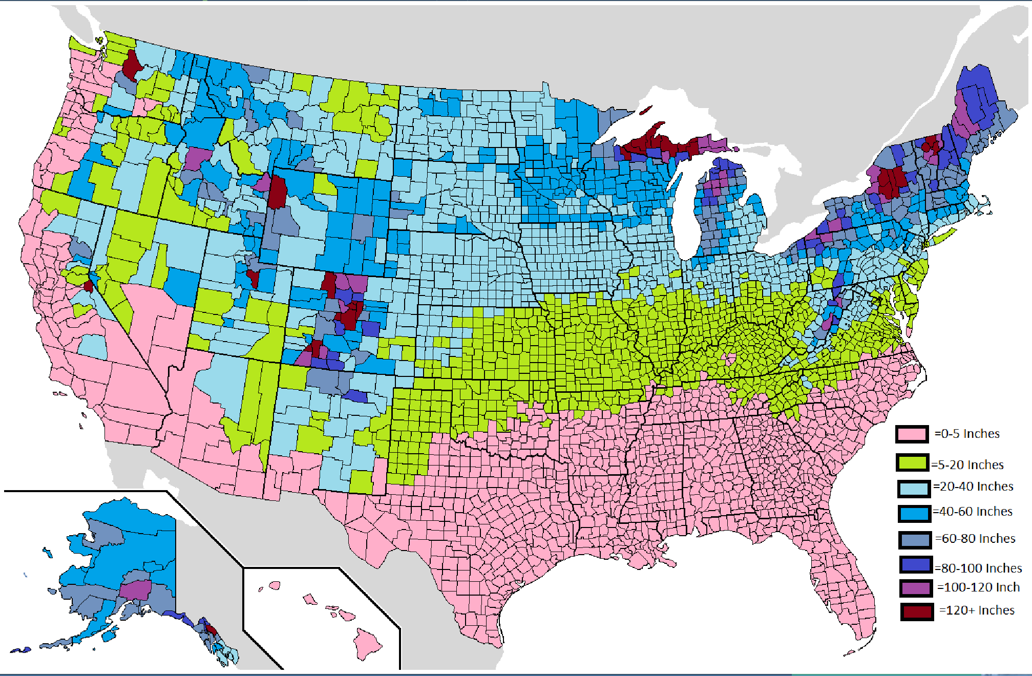
US average annual snowfall map
5. Energy Production
In a world in which greenhouse gas emissions are highly taxed, it would no longer be viable for Ontario to import so many manufactured goods from Asia, since Asia is so far away and relies on burning coal to power its industrial activity. Ontario would instead have to manufacture more products locally, making up for its lack of low-wage labour by using machines, having foreign engineers and other skilled labour e-commute from afar, etc. Such industrialization, particularly as it will depend on machines to assist or replace human workers, will need a lot of low-carbon energy.
Niagara Falls hydro (not counting the American side of the border) accounts for around 5-6 percent of Ontario’s power generation capacity, but more than 7 percent of non-fossil fuel generation capacity and more than 20 percent if you also ignore nuclear power. Niagara accounts for about a quarter of all Ontario hydropower, and its dams also happen to be located far further south than the majority of other dams in the province or country, meaning that the energy and capital used to maintain Niagara’s dams (and to maintain the electricity grid infrastructure that is connected to them) tends to be less than it is for other hydroelectric facilities. Most of Ontario’s other dams are either located near to or north of Ottawa - far north, in many cases - while most of the hydropower in the country comes from central or northern Quebec.
In addition, the hydropower facility on the US side of Niagara Falls produces 25 percent more power than those on the Canadian side of the Falls; it produces more power than all but three other dams in the United States and accounts for nearly 60 percent of New York state’s hydropower (and New York ranks third in hydropower among US states). It also has a pumped storage capability that by itself is larger than the hydropower storage available in all of Ontario outside of Niagara, which is significant since hydro-storage remains the leading method of assisting intermittent energy sources like wind and solar. (Batteries are still not generally up to the job of storing energy in a cost-effective or eco-friendly manner, in spite of all the hoopla surrounding Tesla).
Niagara is, similarly, home to nearly all of Ontario’s pumped storage hydro capacity. Moreover, it is located relatively close to the pumped storage facilities across the United States (apart from the pumped storage in California, but those have been under-utilized in recent years as a result of drought), not just those on the US side of Niagara Falls.

Niagara is also, along with the rest of Southwestern Ontario and the adjacent Bruce Peninsula, home to most of the province’s wind power production and solar power potential.
While 60 percent or so of Ontario’s electricity comes from nuclear, people do not want to live in urban areas that contain nuclear facilities. In addition, more than half of Ontario’s nuclear power capacity is located directly on the coast of Lake Ontario, 30-60 km east of downtown Toronto, which means that, when you combine their output with that of Niagara’s dams (not even counting the US Niagara dams), the coastlands of western Lake Ontario account for more than 40 percent of Ontario’s non-fossil fuel power capacity and nearly 40 percent of Ontario’s overall power capacity.
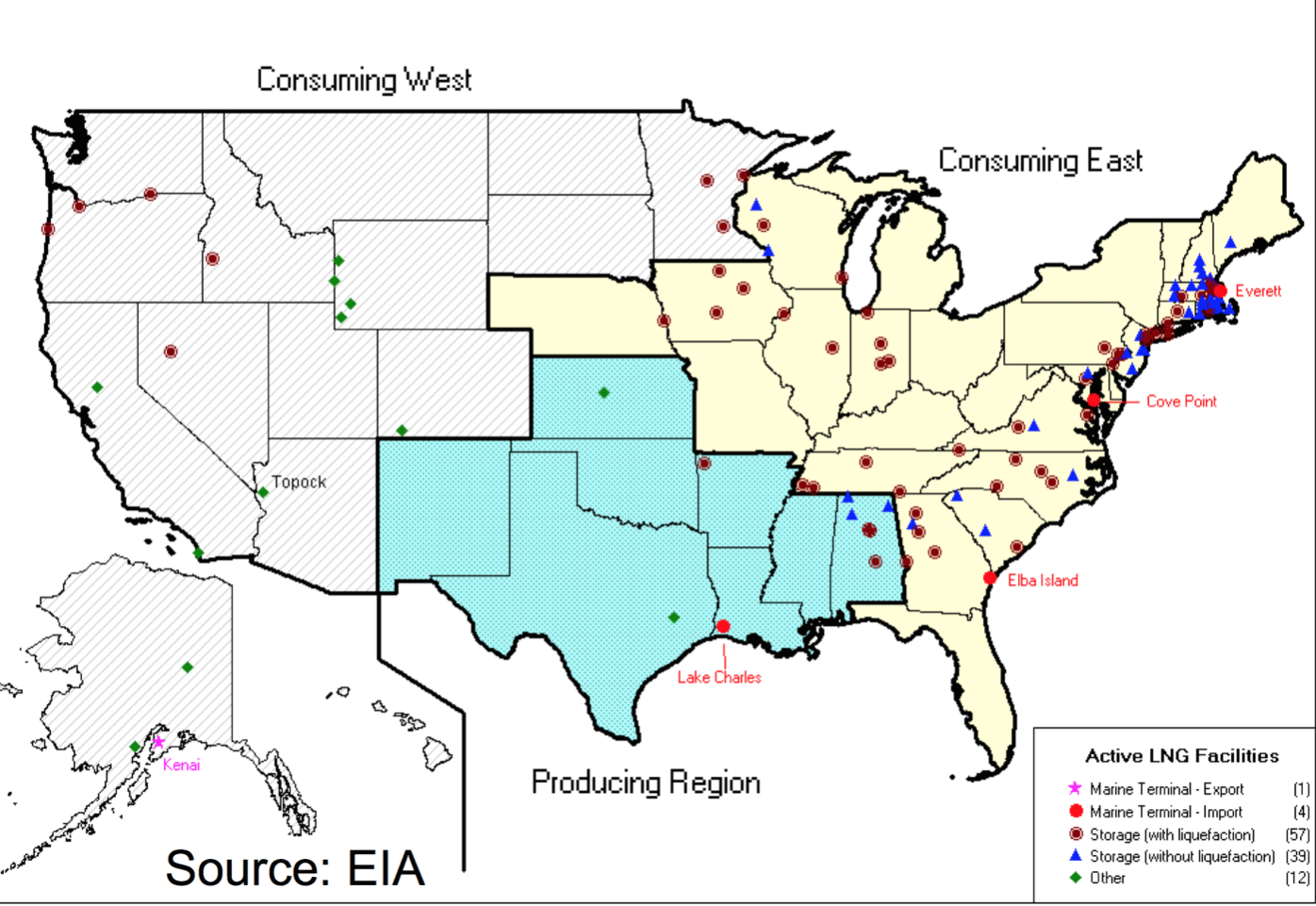
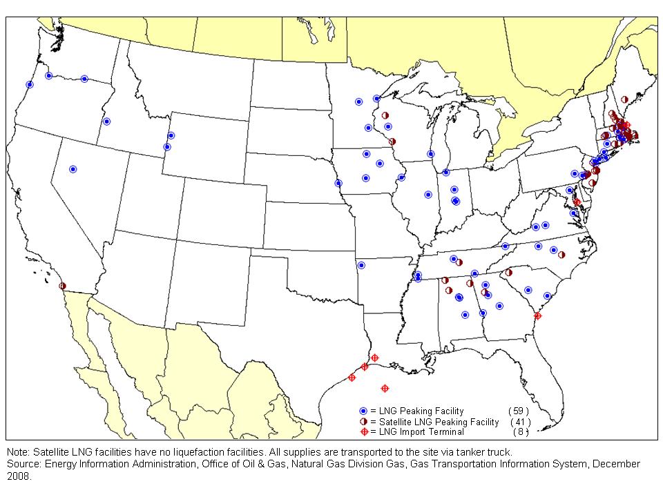
If, finally, you look at natural gas storage - both underground storage and LNG storage - Niagara is also well-placed. Natural gas could be useful in assisting intermittent sources like solar and wind, because like hydro, but unlike coal or nuclear, a gas-fired power plant can ramp up and down energy rapidly in response to the wind suddenly slowing or the sun suddenly being blocked by clouds. Most US underground storage is surrounding Niagara, in a broad sense.
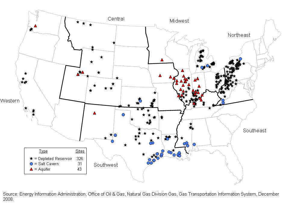
In Ontario, which in contrast to the US has very little gas storage capability, much of the gas storage is around Sarnia, with potential further development in Goderich, both of which are not too far away from Niagara. Most LNG storage and peakshaving capacity, meanwhile — which, while smaller in scale than underground storage, is better for delivering gas quickly in order to assist wind or solar intermittency — is located mostly on the Northeast coast, much of it within New York state.
The gas pipelines that bring US gas to Ontario also mainly run through or near to Niagara. Ontario used to get its gas from Western Canada, but with the shale boom in nearby US states, particularly in Pennsylvania which has led the shale gas boom, the province has begun to use US gas instead. The shale boom has revolutionized the gas industry, and should it continue it is likely to put the border areas of Ontario in a strong position relative to non-border areas, energy-wise.